
Deed Plotter · Right-of-way teams

A corridor of deeds, checked and delivered as one file.

Drop in the deeds for a route. The reader drafts each call table and you verify it. Ellicott checks the tracts against each other, names the gaps and overlaps, and lists every deed it could not read with the reason. The batch comes back as one file. Nothing to install.

Open now Team is $199 a month and carries the combined batch outputs. Start free. No AI model reads your deed.
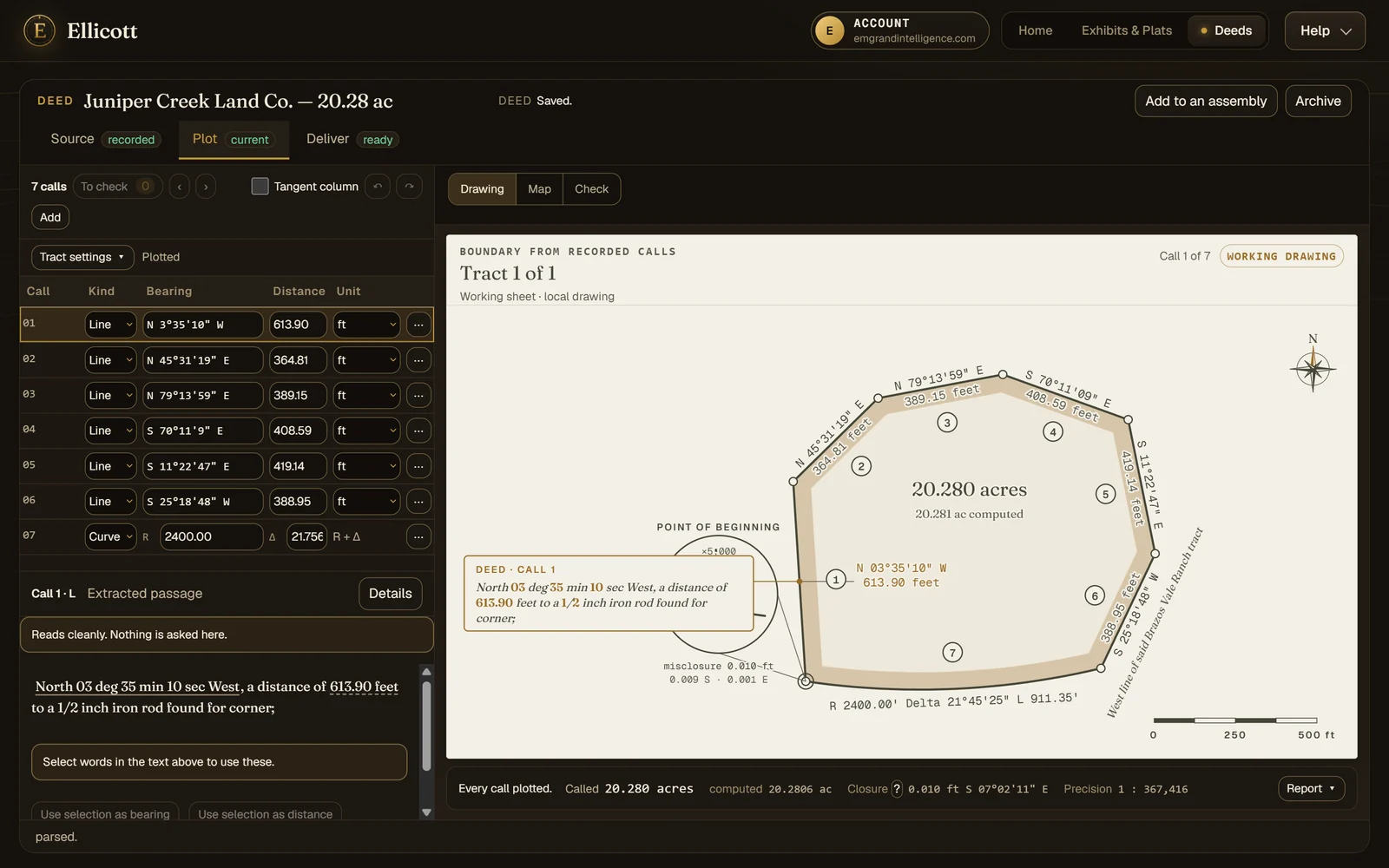
The deed plotter with a seven-call demonstration tract: the call table on the left, the drawing with each bearing and distance labelled, and the closure, precision and area under the drawing.

A demonstration deed: seven calls and a road-frontage curve, closing to 1 in 367,416.

Deed Plotter · Right-of-way teams · under a minute

Drag in a deed, and see whether it closes.

A corridor joined on its shared lines, and the gap no deed describes named.

Demonstration deeds with fictional names. A deed plot is a working drawing, not a boundary survey.
How it works

Read. Check. Place. Assemble.

Each step keeps its evidence in view: the words a call came from, how far the figure misses closing, and where the tract sits on the ground.

01 · Read

Every call, beside the words it came from.

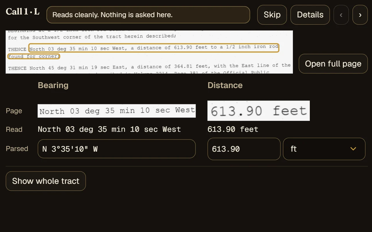
Drop in whatever the courthouse gave you. Scans and photos are read on our servers into a call table. For a scanned page, the Check view puts the page itself beside what was read and the value it became, so a misread is something you see rather than something you trust. A clean description often plots on the first read. A harder one stops at the call that needs you and says why, rather than drawing a guess.
  • Scanned PDFs, images, phone photos, Word, plain text and call-list spreadsheets
  • Words the scan reader was unsure of are marked beside the page
  • Calls read from a scan wait for your check before they can be exported
  • Bearings as quadrants, azimuths, or deflection and interior angles turned left or right, in feet, varas, chains, rods, links or meters
The Check view for one call of a scanned deed: the line cut from the page with the call outlined, the bearing and distance cut from the page above the text read from them, and the parsed values below.
02 · Check

Won't close? See why.

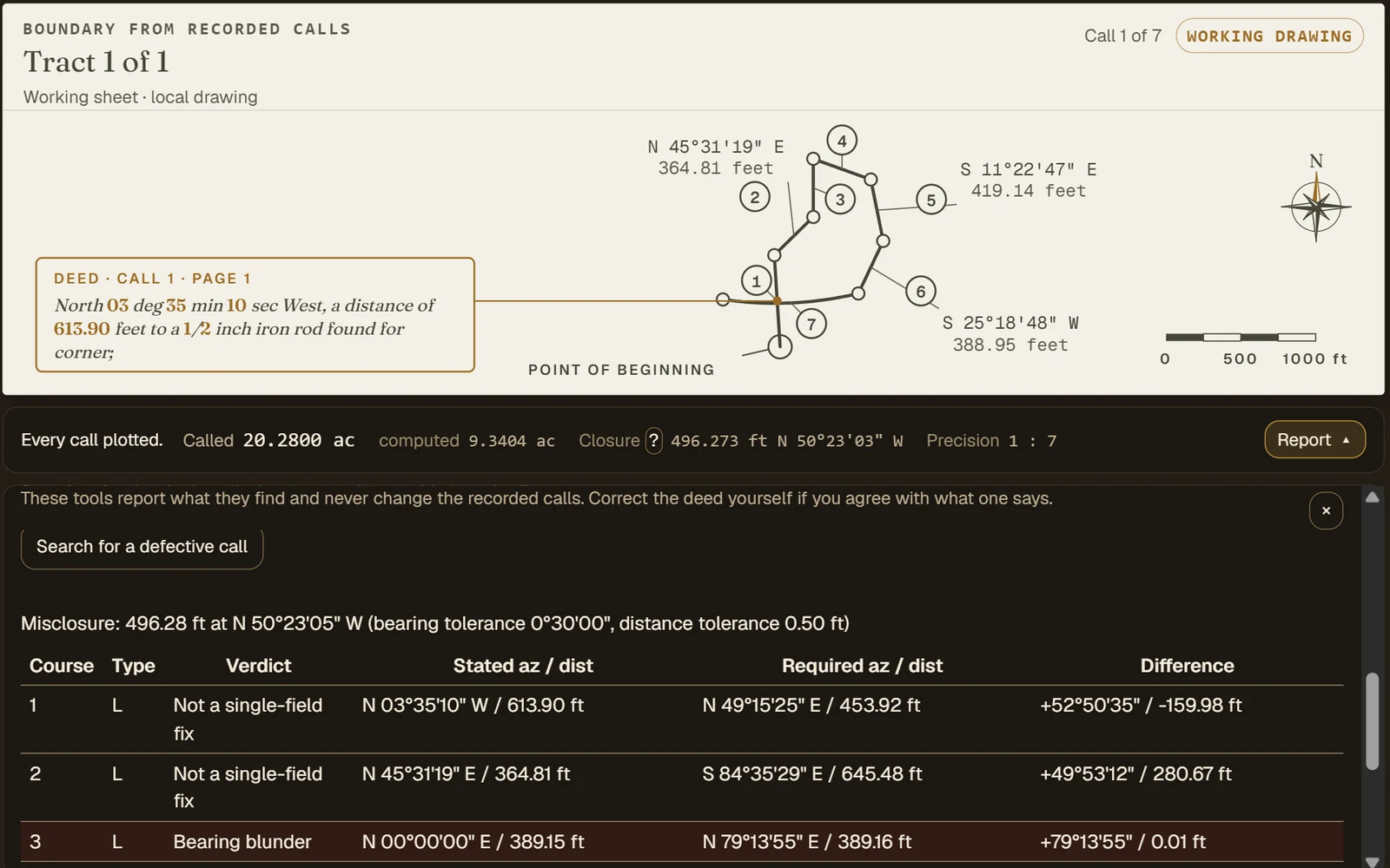
Closure error and direction, the precision ratio and the computed area against the deed's own acreage sit under the drawing the whole time. When a figure misses, the defective-call search looks for the single call whose bearing or distance would close it, and shows what that call would have to be. Not every deed closes as written: when no single call explains the miss, Ellicott says so and leaves the figure as the deed describes it, rather than forcing it shut. It reports; your calls only change when you change them. The Check tab compares each call with its page; the adjustments, ground-to-grid and defective-call search are under Report.
  • Ask what a suspect call would have to be for the figure to close, and judge it yourself
  • When one call is all that keeps a figure from closing and what was read agrees with closure, fill it from the stop message or the Check tab, and undo it
  • Compass (Bowditch), Transit and Crandall adjustments with a before-and-after report
  • Ground-to-grid scale factor, with both areas shown
  • Every plot carries a grade that says what was checked, and what wasn't
A scanned demonstration deed whose third call was read without its angle, so the figure misses by 496 feet. The defective-call search names call 3 as a bearing blunder and gives the bearing that closes the figure.
03 · Place

On the ground from the first click.

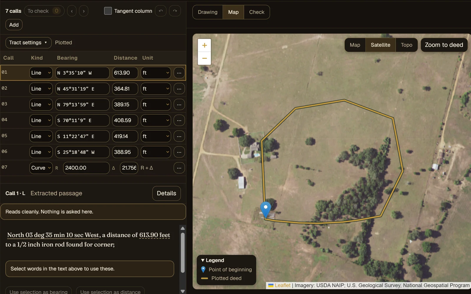
Set the point of beginning by clicking the map, typing coordinates, or taking the coordinates the deed itself states. Ellicott reads the county, survey and abstract out of the text to take you to the right place, then draws the tract in its state plane zone over aerial imagery.
  • State plane zones offered for the location, US survey feet handled
  • Aerial, street and topographic backgrounds
  • Texas original surveys, and PLSS sections and aliquot parts, drawn from public survey records as a guide
  • Promote a placed deed straight into an exhibit project
The demonstration tract drawn over aerial imagery, beside the call table it was plotted from, with its point of beginning marked.
04 · Assemble

Adjoining deeds, and the ground between them.

Put neighboring deeds together, snap a corner to a corner or a line to a line, or fit a deed to found monuments with the rotation stated back to you. Then check every gap and overlap, with its area and the senior deed named.
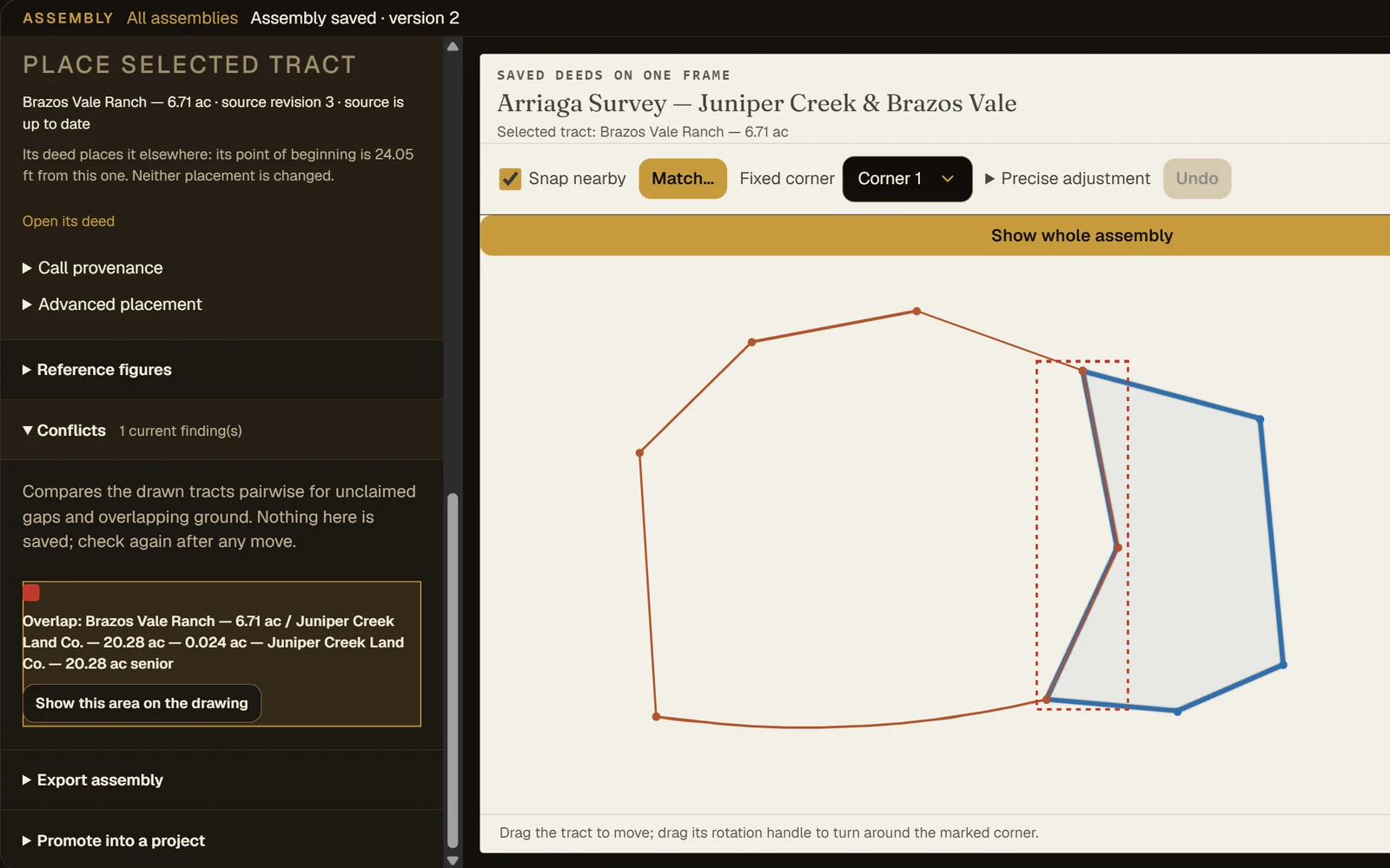
  • Seniority recorded per tract and applied to each conflict
  • Reference figures alongside the deeds: a nominal section, a centerline easement or an offset parcel
  • Versions of the assembly kept, and reopened where you left them
  • Export the assembly as a GeoPackage or DXF
Two adjoining demonstration deeds on one frame, ranked by seniority, with a 0.024 acre overlap found along their shared line and the senior deed named.
05 · Batch

A whole corridor in one drop.

Drop a folder or a zip of deeds. Each file is read on its own, so one bad file never holds up the rest, and the results come back sorted by how much work each tract still needs: plotted, a quick review, or more. The one deed that needs you is the one you open.
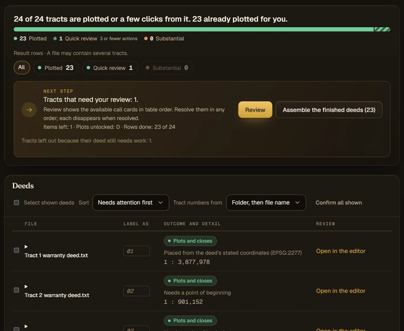
  • Scans, Word and text files mixed in one package
  • A folder per tract numbers the tracts for you
  • Reading a batch is not billed
A finished batch of 24 demonstration corridor deeds: 23 plotted and one held for a quick review, with the next step and the deed table below.
06 · Join

Shared lines, checked against both deeds.

Ellicott finds the calls two deeds in a batch share and proposes each one as a join, with how far the two calls agree. Compare them as recorded, then accept or reject. An accepted join lets one placed tract place its neighbors.
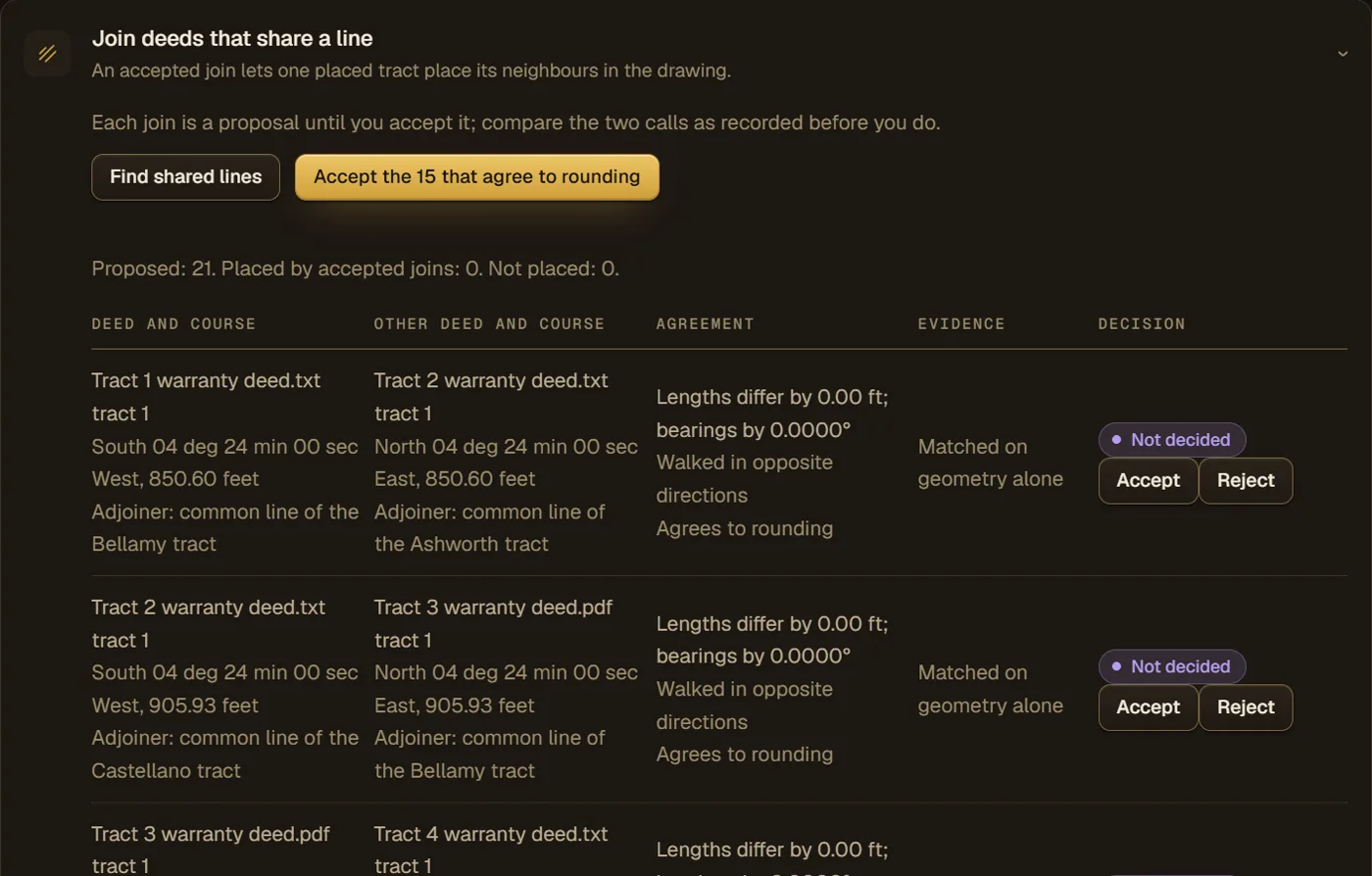
  • The joins that agree to rounding can be accepted together
  • Each decision is recorded as yours
Shared lines found between neighboring demonstration deeds, each with both deeds' calls side by side, how far they agree, and a decision to accept or reject.
07 · Deliver

One package, in the formats your office uses.

Pick a preset for CAD, for GIS, or for the plat and the office, and deliver every deed that plots in one zip. With the CAD link set up, the package goes straight into the drawing you have open. One deed at a time, the same presets choose the format for you.

  • Every deed as one DXF, or one file per deed
  • A search sheet of each deed's monuments and ties alongside
  • A spreadsheet in every zip says where each file is and why anything was left out
08 · Field

The field package, as a link.

Send a crew one link to the monuments, ties and adjoiner corners a set of deeds call for, in each deed's own words, so nothing has to be printed. It is a record search aid: it carries no coordinates. Your surveyor gives the crew the coordinates they work to.

  • The record the crew searches from, readable on a phone
  • A search sheet to save as a PDF
  • The link shows the deeds as saved when it was made, and stops working when it expires
Capabilities

What to ask of any deed plotter.

Six things worth asking of any tool that reads deeds, and what Ellicott does about each. Where it does not do something, the list says so.

Reading

  • Scans and phone photos read on our servers
  • Each call checked against a crop of the page it came from
  • Text the reader could not classify is shown, never dropped silently
  • Several tracts in one instrument, each with its own call table
  • Curves from whichever values the deed states
  • Batch intake for a stack of corridor deeds
  • Typed and printed deeds, clean or scanned. Cursive handwriting is not read; type those calls in and the checks still run

Survey math

  • Closure error, direction and precision ratio
  • Called area against computed area
  • Compass, Transit and Crandall adjustments
  • Force-closure diagnostic and single-blunder search
  • Gap and overlap areas between deeds, with seniority

Output

  • Printable exhibit sheet (PDF)
  • DXF for CAD, or straight into an open CAD drawing through the CAD link
  • Shapefile, GeoPackage and GeoJSON with record bearing, distance and curve data on each line
  • KML and Esri traverse file
  • A metes-and-bounds description written from the plotted calls, as text or Word
  • Call table spreadsheet and the deed record in Word

Map

  • Point of beginning by click, typed coordinates or the deed's own
  • County, survey and abstract read from the text
  • State plane zones, with aerial, street and topographic backgrounds
  • Texas surveys and PLSS aliquot parts drawn as a guide

Title work

  • A deed record kept with the plot, with values offered from the text
  • Two descriptions compared side by side
  • Shareable read-only link to a plotted deed
  • A field package for the crew, as one link

Working together

  • Runs in any modern browser, on any operating system
  • Organization accounts, not machine-locked seats
  • Version history for every deed and assembly
How it reads

Evidence you can check, not a guess you have to trust.

Every call traced to the page. Every inference marked.

Each number in the call table points back to the words it was read from. Where the deed is ambiguous, Ellicott flags the call and stops rather than choosing for you. Where it can offer a value the deed implies, the value carries a dagger mark (†) until you accept it, and a call read from a scan is not exported until you have checked it.

Your documents stay with the work.

Deeds are read by recognition software on our own servers. They are never sent to an AI model or an outside service to be read.

Pricing

Free to plot. A plan when the exports add up.

Reading, plotting, checking and placing deeds cost nothing, and your first export is free. After that, buy one deed's export at a time, or take a plan for the office. A plan covers the office, not one computer.

Free

$0

  • 15 deeds read a month, in batches of up to 10
  • First export free, then $15 for each deed's export
  • Deeds kept 30 days

Solo

$49 per office, per month

  • Up to 3 people in one office
  • 100 deed exports a month included, then $1 each
  • Batches of up to 50 deeds
  • CAD, GIS and printable exhibit for every deed

See the full pricing sheet →

Plot your hardest deed free.

See where it closes, and where it doesn't. No install, and your first export is free.

Start free