
Ellicott · Deed Plotter

From deed text to a closed, placed boundary.

Bring in a scanned deed, a phone photo, a Word file or pasted text. Ellicott reads the calls, draws the figure, tells you how well it closes, and puts it on the ground beside its neighbors. It all runs in the browser, with nothing to install.
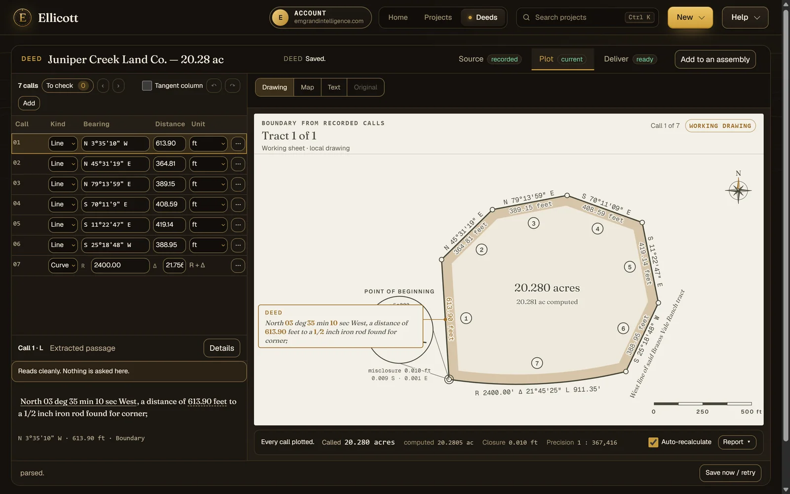
The deed plotter showing a seven-call tract drawn from its recorded calls, with the call table beside it and the closure and precision shown below the drawing.

A demonstration deed: seven calls, a road-frontage curve, closure and area reported without asking.

How it works

Read. Check. Place. Assemble.

Each step shows its evidence beside it: the words a call came from, how far the figure misses closing, and where the tract sits on real imagery.

01 · Read

Any deed in, a call table out.

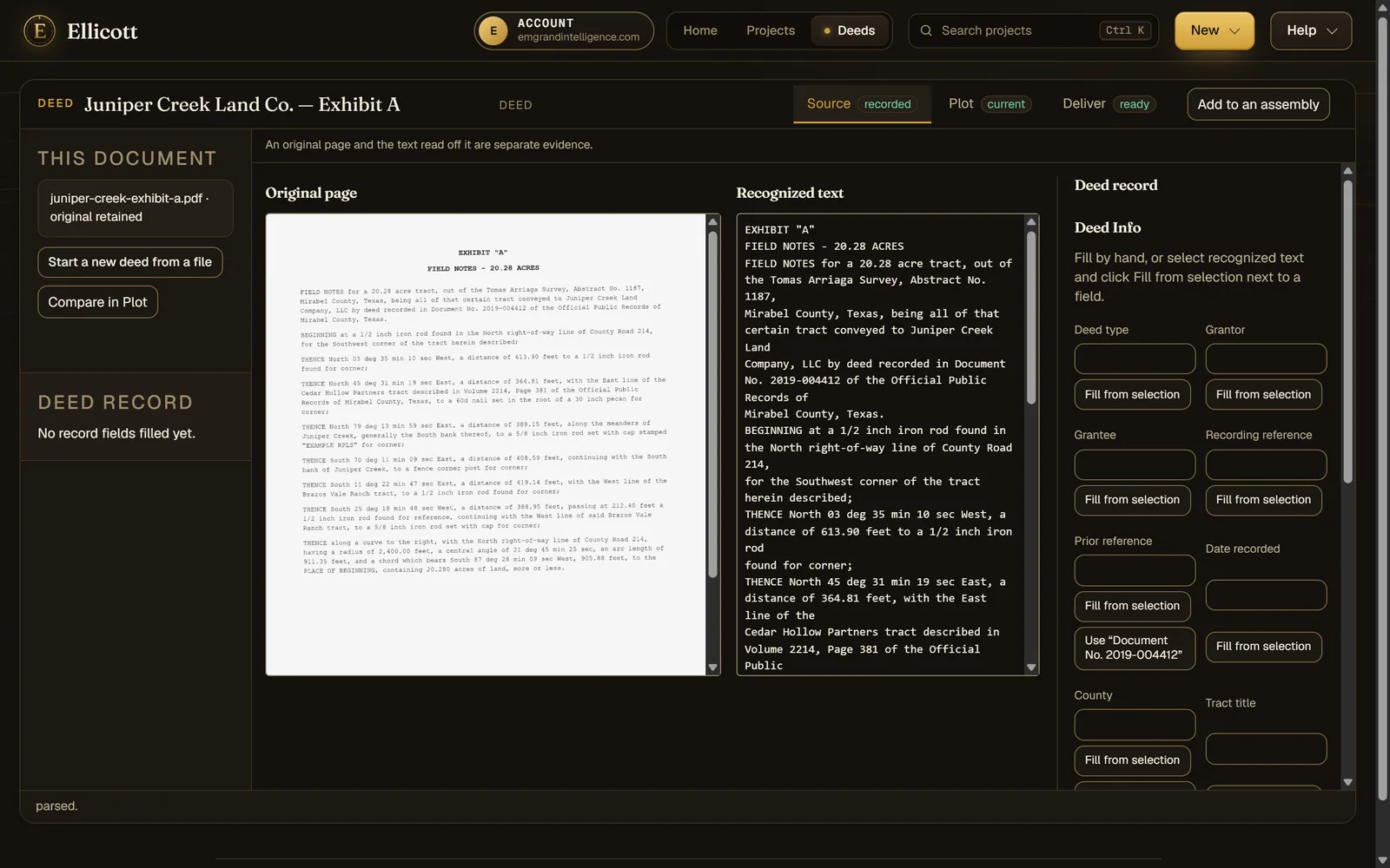
Drop whatever the courthouse gave you. A scan or photo is recognized on our servers, and every call keeps a link to the words it came from. When the scan was hard to read, the call is marked so you check it instead of trusting it.
  • Scanned PDFs, images, phone photos, Word, plain text and call-list spreadsheets
  • Several tracts in one instrument, each with its own call table
  • Bearings as quadrants, azimuths, deflections or interior angles
  • Feet, varas, chains, rods, links and meters, including mixed units
  • Curves from whichever values the deed states
A scanned typewritten deed shown beside the calls read from it.
02 · Check

Closure, precision and area, before you ask.

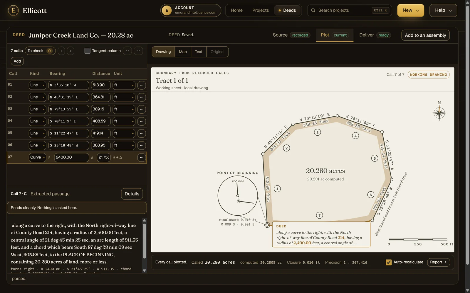
The figure redraws as you correct a call. Closure error, its direction, the precision ratio and the computed area against the deed's own acreage sit under the drawing the whole time.
  • Ask what a suspect call would have to be for the figure to close, and judge it yourself
  • Search for the single call whose bearing or distance was likely miswritten
  • Compass (Bowditch), Transit and Crandall adjustments with a before-and-after report
  • Ground-to-grid scale factor, with both areas shown
The closing curve selected, with the deed passage it was read from and the magnified misclosure at the point of beginning.
03 · Place

On the ground from the first click.

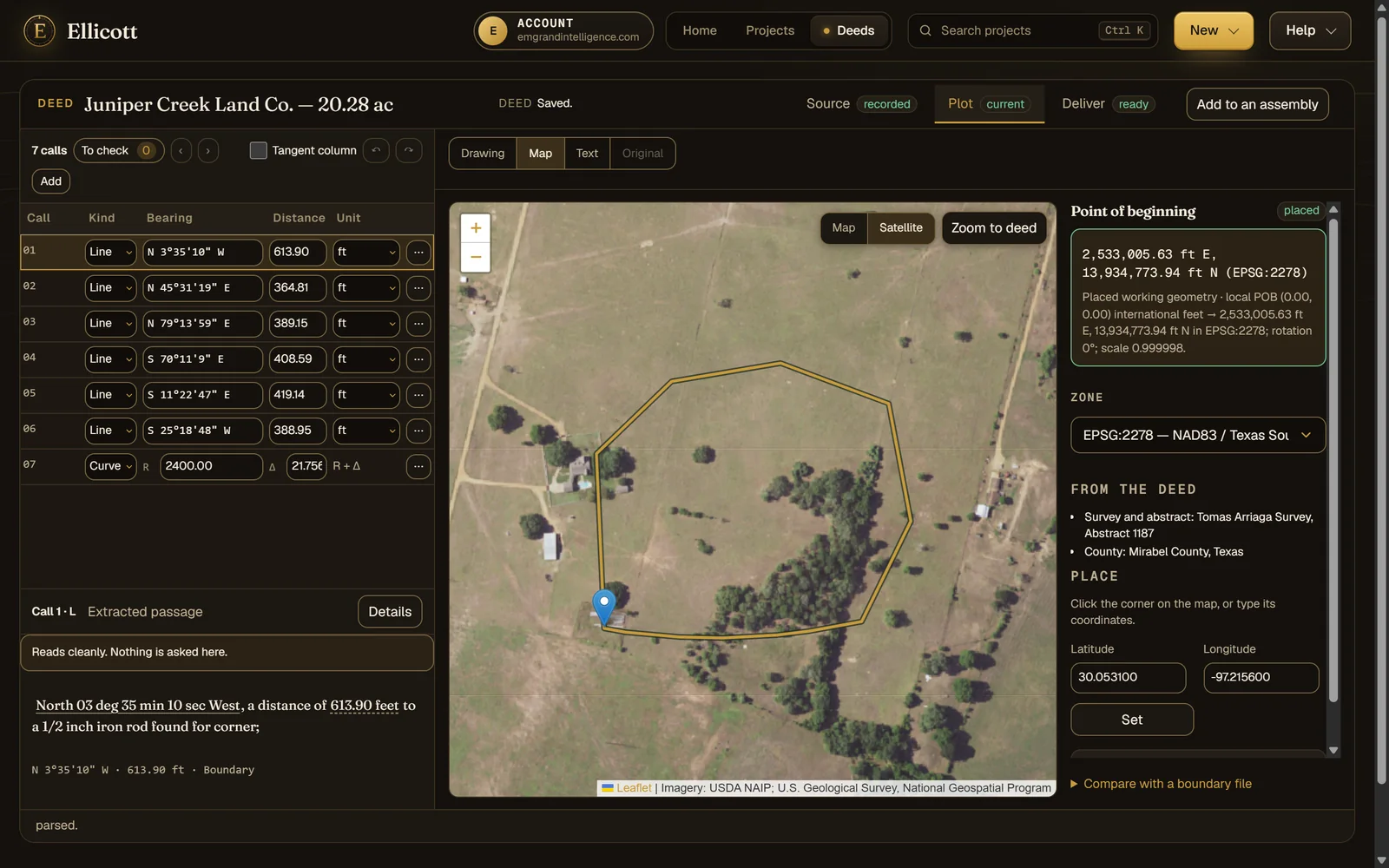
Set the point of beginning by clicking the map, typing coordinates, or taking the coordinates the deed itself states. Ellicott reads the county, survey and abstract out of the text to take you to the right place, then draws the tract in its state plane zone over aerial imagery.
  • State plane zones offered for the location, US survey feet handled
  • Aerial imagery under the tract
  • Promote a placed deed straight into a plat project
The demonstration tract drawn over aerial imagery with its point of beginning and state plane coordinates.
04 · Assemble

Adjoining deeds, and the ground between them.

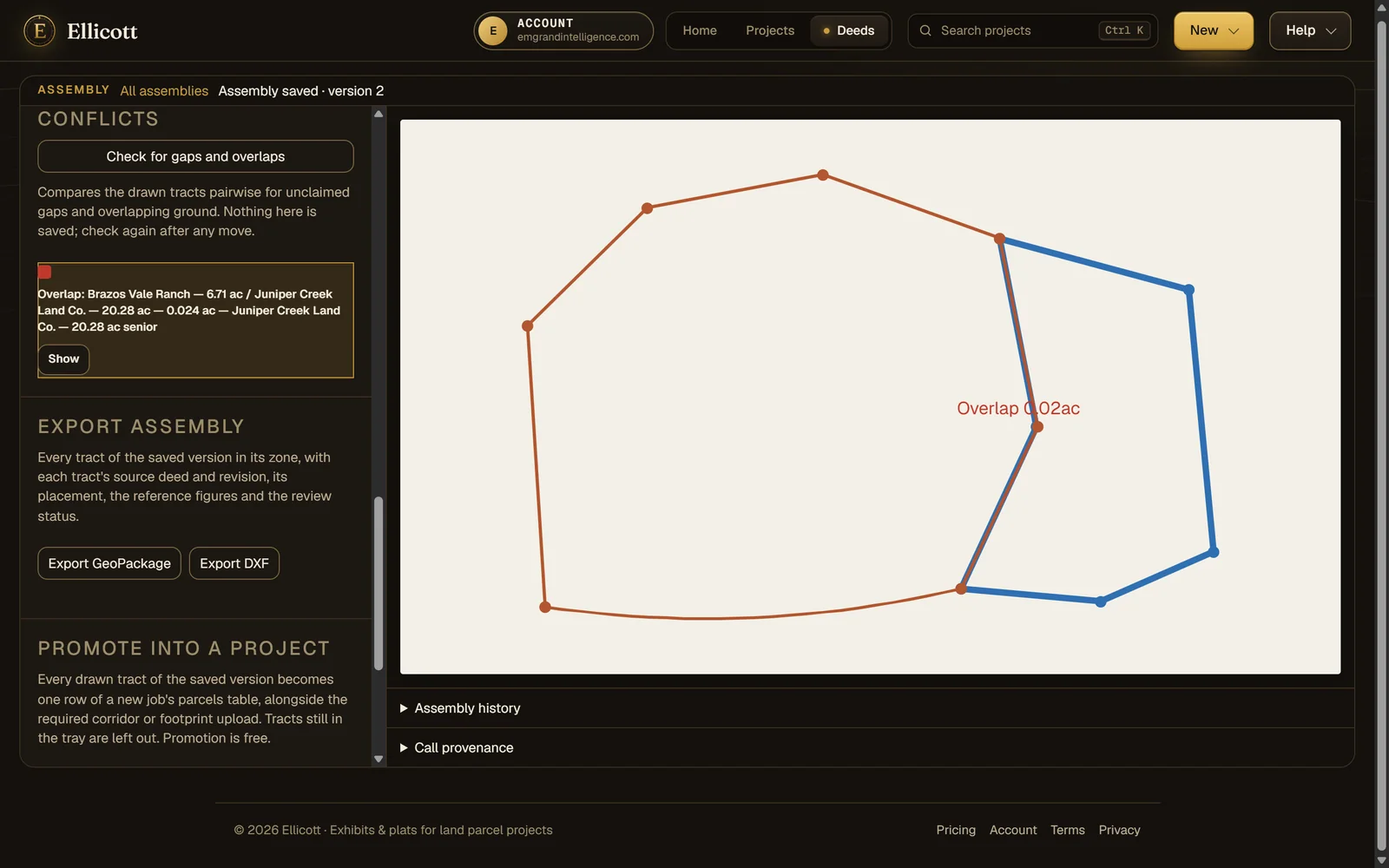
Put neighboring deeds together, snap a corner to a corner or a line to a line, or fit a deed to found monuments with the rotation stated back to you. Then check every gap and overlap, with its area and the senior deed named.
  • Seniority recorded per tract and applied to each conflict
  • Versions of the assembly kept, and reopened where you left them
  • Export the assembly as a GeoPackage or DXF
Two adjoining deeds assembled, with an overlap sliver of two hundredths of an acre found along their shared line.
Capabilities

What a desktop deed plotter does, and what it can't.

The work a surveyor expects from a deed plotter, plus the survey math, mapping and teamwork that a single-seat desktop tool leaves out.

Reading

  • Scans and phone photos read on our servers
  • Per-call marks where the scan was hard to read
  • Text the parser could not classify is shown, never dropped silently
  • Passing monuments and adjoiners kept with each call
  • Batch intake for a stack of corridor deeds

Survey math

  • Closure error, direction and precision ratio
  • Called area against computed area
  • Compass, Transit and Crandall adjustments
  • Force-closure diagnostic and single-blunder search
  • Gap and overlap areas between deeds, with seniority

Output

  • Printable plat sheet (PDF)
  • DXF for CAD
  • Shapefile, GeoPackage and GeoJSON with record bearing, distance and curve data on each line
  • KML, Esri traverse file and point file
  • Call table spreadsheet and the deed record in Word

Map

  • Point of beginning by click, typed coordinates or the deed's own
  • County, survey and abstract read from the text
  • State plane zones and aerial imagery

Title work

  • A deed record kept with the plot, with values offered from the text
  • Two descriptions compared side by side
  • Shareable read-only link to a plotted deed

Working together

  • Runs in any modern browser, on any operating system
  • Organization accounts, not machine-locked seats
  • Version history for every deed and assembly
How it reads

Evidence you can check, not a guess you have to trust.

Every call traced to the page. Nothing guessed.

Each number in the call table points back to the words it was read from. Where the deed is ambiguous, Ellicott flags the call and stops rather than choosing for you.

Your documents stay with the work.

Deeds are read by recognition software on our own servers. They are never sent to an AI model or an outside service to be read.

Pricing

Plot for free. Pay when you take a file.

Reading, plotting, checking and placing a deed cost nothing. One purchase covers every export of a deed file, in every format, through later edits. A monthly deed plan includes exports.

  • 01 Free to read, plot, check closure and place on the map
  • 02 Per-deed purchase covers every format and later edits of that deed
  • 03 A monthly deed plan includes exports for regular volume

Current prices are on the pricing page →

Bring us your hardest deed.

Send a description that gave your team trouble. We'll plot it with you and show you where it closes and where it doesn't.

Request access